The Mining History of Texada Island dates back to the late 1800's when gold was discovered in volcanic hosted quartz veins in the Surprise Mountain area. This led to further discoveries of gold, copper and iron, and the establishment of several small mines at the turn of the century.

Thursday, January 12, 2012

Texada Island

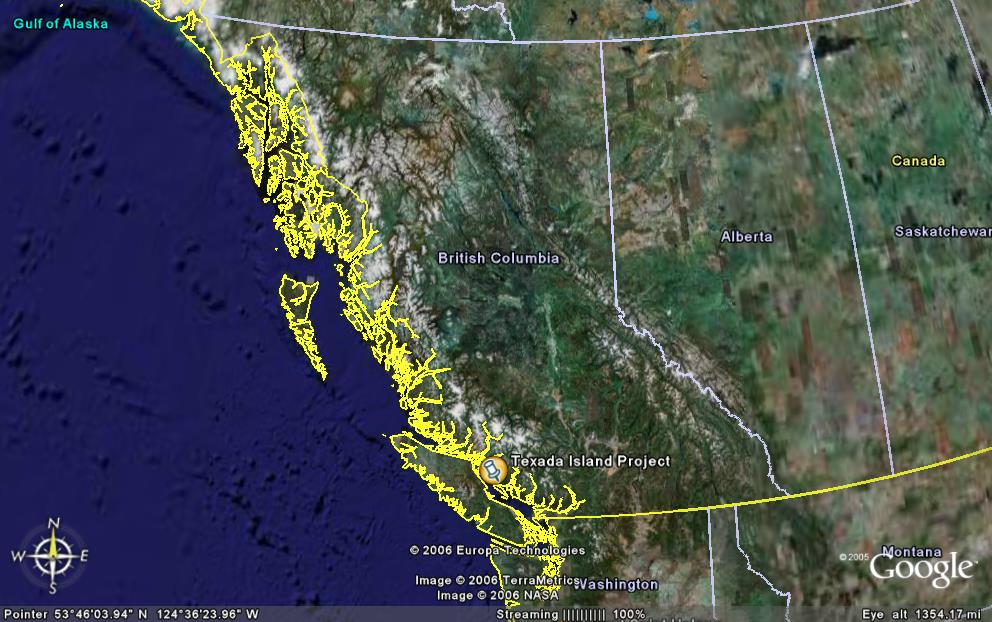
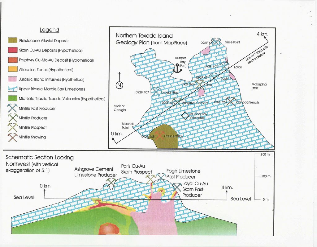
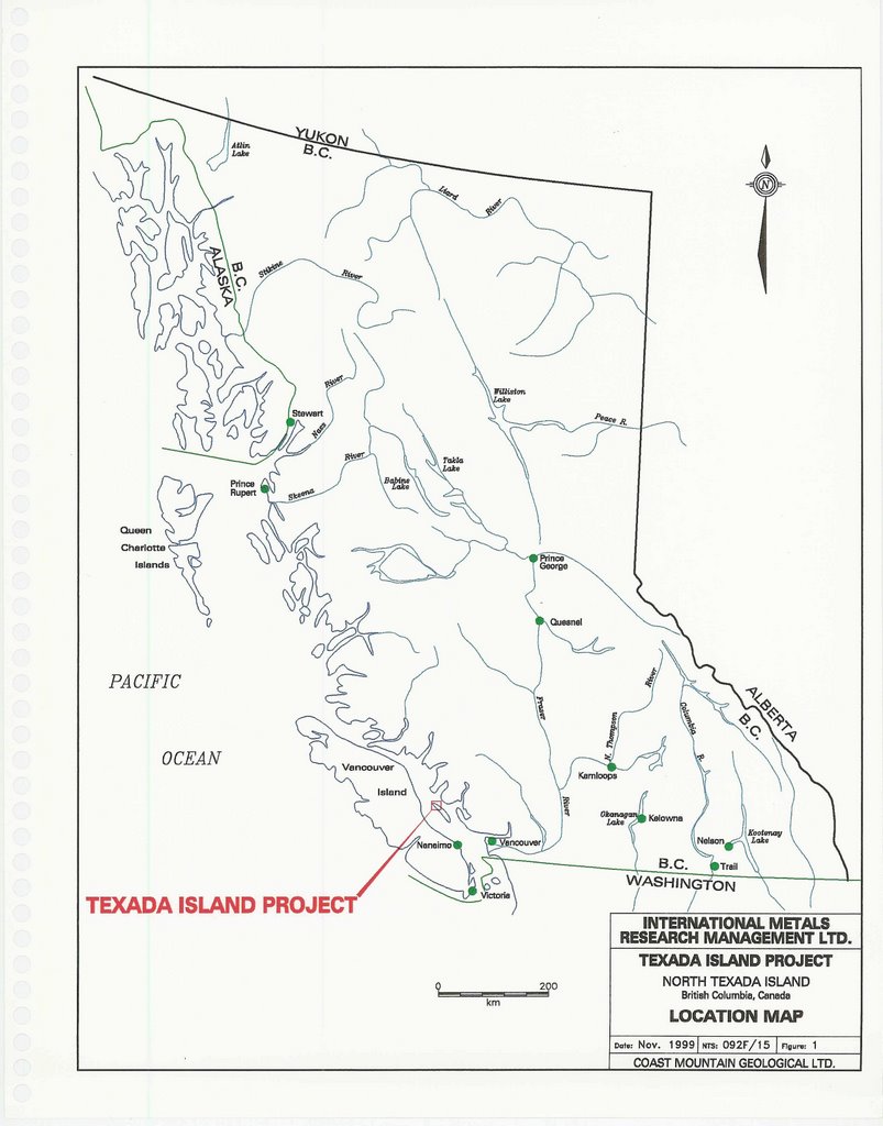
The Property encompasses the northern portion of Texada Island, one of a group of Islands collectively known as the Gulf Islands, in the Strait of Georgia between the mainland and Vancouver Island. Located within the Nanaimo Mining District, the property’s geographical coordinates are: North Latitude: 49 Degrees 50’, West Longitude: 124 degrees 34’ (NTS Map sheet 092F/15).

Located approximately 120 kilometers northwest of Vancouver, British Columbia, Texada Island is readily accessible by air or by ferry, and benefits from a well developed infrastructure of services, tidewater access and transportation methods.

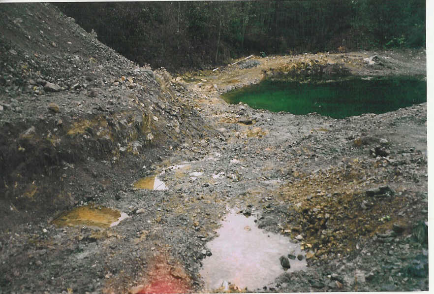
The island is characterized by low relief with poor to moderate outcrop exposure due to variable thicknesses of glacial till. Small diameter spruce and fir with relatively little undergrowth constitute the dominant vegetation. Climate is generally mild and average annual precipitation is in the order of 70 to 100 cm, falling mostly in the late fall and winter months. Fieldwork is possible year round.

Texada Island History

The Mining History of Texada Island dates back to the late 1800's when gold was discovered in volcanic hosted quartz veins in the Surprise Mountain area. This led to further discoveries of gold, copper and iron, and the establishment of several small mines at the turn of the century.
The two most significant producers were the Texada Iron Mines (approximately 10 million tons of iron ore concentrate and 1,897 ounces of gold to 1977, when production ceased) and the Marble Bay Mine, which produced 50,001 ounces of gold from 314,200 tons from 1899 to 1929. Overall historical island production is estimated at over 105,000 ounces. In addition, a number of limestone quarries have operated over the years, and some continue to do so at present.

Texada Island Regional Geology

Texada Island is underlain by two Upper Triassic Formations -The volcanic Texada Formation and the limestone Marble Bay Formation - which have been equated to the Karmutsen and Quatsino Formations respectively of the Vancouver Group on Vancouver Island.
The Karmutsen rocks are a thick package of tholeitic basalts unconformably overlying the Paleozoic Sicker Group of sediments exposed at the southern end of the island. The Quatsino limestone unit is a thick package of massive to well bedded platform chemical sediments disconformably overlying the volcanics. Rocks of the Mid to Upper Jurassic Island Plutonic Suite (formerly know as the Island Intrusives) intrude this sequence, as does a later, possibly Tertiary, event in the form of east west trending dykes which cut all units.

Major structural features include folding and faulting prior to emplacement of the Island Plutonic Suite. The limestones and, to a lesser extent, the volcanics are deformed into a series of broad, northwest-trending open folds that plunge northward. Three northwest-striking lineaments, the Ideal, Holly and Marble Bay faults cut a set of northeasterly-trending faults, East-west structures are the youngest and control the emplacement of the Tertiary dykes. It appears that the Marble Bay and, to a lesser extent, the Ideal faults controlled emplacement of some of the Jurassic intrusions and their associated skarn mineralization.
Mineralization on the island occurs in two main forms - skarn assemblages and quartz- carbonate veins. While the latter first attracted attention, the former has been the source of most of the mineral production on Texada.

Skarn mineralogy is extremely varied and complex, and generally not mappable on a property scale, however it can be divided into two basic types: iron-rich and copper-gold rich. Iron - rich skarns are concentrated along either the Marble Bay-Texada Formation contact, margins of the felsic Gillies Stock or some distance from the stock in either rock type, controlled by subvertical fractures (Prescott, Yellow Kid, Paxton and Lake deposits, operated by Texada Mines).

Magnetite orebodies adjacent to the stock are generally associated with abundant garnet-pyroxene-amphibole skarn while more distal deposits have less extensive skarn envelopes. Contacts between skarn and unaltered rock are generally sharp. Zoning, where fully developed, consists of barren skarn close to the intrusion, grading outward to magnetite-rich skarn and then into marble. Locally, chalcopyrite and pyrite occur close to the outer margins of the skarn envelope, adjacent to limestone or marble.

Copper-gold skarns are more widely distributed and variable in mineralogy, occurring throughout the limestone unit and generally associated with more mafic dioritic intrusions. The most significant of these deposits are associated with the Marble Bay fault southeast of the town of Vananda and include the Marble Bay, Little Billy, Cornell and Copper Queen mines. Main ore minerals are chalcopyrite and bornite with variable but minor amounts of molybdenite, pyrite, magnetite and sphalerite. Less developed occurrences include the Paris and Loyal mines, and the Canada Trench, near Blubber Bay at the north end of the island.

Quartz and carbonate veins, carrying a varied suite of base and precious metals, are mostly located in or adjacent to north or northwest-trending faults or shear zones that cut the Karmutsen volcanics underlying the Surprise Mountain area. Mineralization includes pyrite, chalcopyrite, galena, sphalerite and gold.


Maps


Yew Project

The Yew Property is centered approximately 1/2 mile (0.8 km) south of the town of Vananda.
On the Yew 7 claim, a thin 10 foot (3.3 meter) limestone tabular bed sandwiched between andesite or basalt flows has been delineated containing massive pyrite, chalcopyrite and magnetite. This gold-copper skarn deposit in the replaced limestone occurs within sheared altered volcanics; adjacent to dioritic instrusives.
The mineralized skarn zone ranges in width from 8 inches to 6 feet (0.2 to 1.8 m) and has been drill tested over an area of 5.9 acres (2.5 ha.).

Recent trenching programs have defined 2 wide vertical shear zones which leaves the Yew deposit open at depth and along strike. The first shear zone intersects the above skarn zone and is approximately 10 to 16 feet (3 to 5 N) wide. Surface grab samples collected within or adjacent to this shear zone average 0.47 oz./ton gold (16.1 g/t gold). The second shear zone is 490 feet (150 H) west of the first and is approximately 95 feet (30 M) wide. Surface grab samples average 0.05 oz./ton gold (1.7 g/t gold) with the highest assay being 0.12 oz./ton gold (4.1 g/t gold). In the near future, a surface drill program is planned to delineate and increase the skarn ore reserves and to test the continuity of both shear zones along strike and at depth. In addition a program will be carried out to identify other drilling targets on the 14 claim property.

The Project has completed an IP (Induced Polarization) Survey on the Yew Pit. The results were extremely positive with the delineation of an ore-body beginning on surface to a depth 200 meters. The approximate size of the ore-body is expected to be approaching Twenty (20) million cubic meters.


Yew Project IP Survey Report


Bolivar Property


This property consists is centered approximately 1.5 miles (2.4 km) west of the town of Vananda.
Gold and silver mineralization is associated with graphitic shear zones along limestone - volcanic contacts and pyrite rich quartz veins hosted in volcanics. Trenching, diamond drilling and bulk test sampling of the Bolivar deposit revealed numerous spectacular "streaks and stringers" of free gold in graphitic shear zones. One diamond drill hole across the zone returned a 1 foot (0.3 m) intersection assaying 20.84 oz./ton gold (714.5 g/t gold). A bulk sample shipment from the Majorie showing of 25 Tons (23 Tons) in 1916 produced $6,500 in receipts from 314.5 ounces (9.78 kg) of gold recovered, equivalent to a grade of 12 oz./ton (411.4 g/t) at the then prevailing bullion price of $20.67 an ounce.

Holly Property


The property is located approximately 2 miles (3.2 km) south of the town of Vananda.

Gold mineralization on the property is associated with pyritic quartz - calcite veining within volcanics and zones of intense shearing. Old records indicate a 100 ton (91 Tons) bulk sample from the "Holly Pit" assayed 1.0 oz./ton (34.3 g/t) gold. In 1914 two Tons (2.2 Tons) of ore shipped from the Gem Mine averaged 12.9 oz./ton (387 g/t) gold and 4.0 oz./ton (137 g/t) silver.

M-21 Project

The property is located along the West Coast of Texada Island approximately 4 - 5 miles (7.2 km) northwest of Gilles Bay.
Gold-copper mineralization occurs in quartz veins and related narrow shear zones. Historical records indicate production from the Retriever Mine during the 1916-17 period was 9 ounces (280 g) of gold, 310 ounces (9640 g) of silver and 25,040 pounds (11,360 kg) of copper from 368 tons (334 Tons) of ore treated.

Surprise Mountain Project

This property is located approximately 2.5 miles (4.0 km) southwest of the town of Vananda.
Precious and base metal mineralization occurs in quartz and quartz - carbonate veins containing variable sulphide content associated with narrow shear zones.


In 1986 a shallow diamond drill hold on the "Silver Tip" shear zone assayed 0.51 oz../ton (17 5 o/t) gold over 1-2 feet (0.37 meters). During the same period a drill hole on the "Nancy Bell" showing intersected a 1 foot (0.30 meter) shear zone assaying 1.98 oz./ton (68.0 g/t) gold at a shallow depth.

Paris - Loyal Project

This property is situated on the extreme northern end of Texada Island, extending across its entire width. The primary exploration target is the occurrence of gold-copper skarn mineralization in limestone associated with both the adjacent volcanic and dioritic intrusives.
Two underground mines, the Paris and Loyal, operated for short periods at the turn of the century. Two surface grab samples from the "Paris Trench" in 1989 assayed 0.41 and 0.38 oz./ton (14.1 g/t and 13.0 g/t) gold. Diamond drilling on the Paris zone by Echo Bay in 1989 intersected several zones of interest including a 5 foot (1.55 meter) interval assaying 0.83 oz./ton (28.5 g/t) gold and 10 foot (3.1 meter) interval assaying 0.23 oz./ton (7.9 g/t) gold.