Texada Island Regional Geology
Texada Island is underlain by two Upper Triassic Formations -The volcanic Texada Formation and the limestone Marble Bay Formation - which have been equated to the Karmutsen and Quatsino Formations respectively of the Vancouver Group on Vancouver Island.
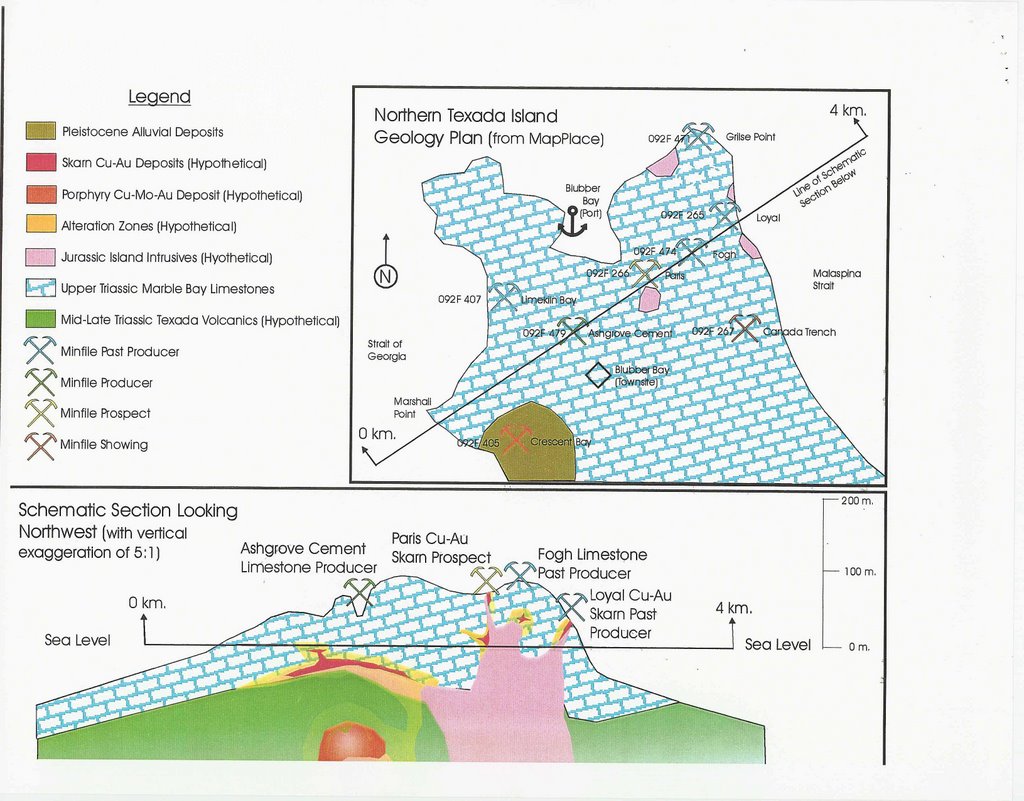
The Karmutsen rocks are a thick package of tholeitic basalts unconformably overlying the Paleozoic Sicker Group of sediments exposed at the southern end of the island. The Quatsino limestone unit is a thick package of massive to well bedded platform chemical sediments disconformably overlying the volcanics. Rocks of the Mid to Upper Jurassic Island Plutonic Suite (formerly know as the Island Intrusives) intrude this sequence, as does a later, possibly Tertiary, event in the form of east west trending dykes which cut all units.
Major structural features include folding and faulting prior to emplacement of the Island Plutonic Suite. The limestones and, to a lesser extent, the volcanics are deformed into a series of broad, northwest-trending open folds that plunge northward. Three northwest-striking lineaments, the Ideal, Holly and Marble Bay faults cut a set of northeasterly-trending faults, East-west structures are the youngest and control the emplacement of the Tertiary dykes. It appears that the Marble Bay and, to a lesser extent, the Ideal faults controlled emplacement of some of the Jurassic intrusions and their associated skarn mineralization.
Mineralization on the island occurs in two main forms - skarn assemblages and quartz- carbonate veins. While the latter first attracted attention, the former has been the source of most of the mineral production on Texada.
Skarn mineralogy is extremely varied and complex, and generally not mappable on a property scale, however it can be divided into two basic types: iron-rich and copper-gold rich. Iron - rich skarns are concentrated along either the Marble Bay-Texada Formation contact, margins of the felsic Gillies Stock or some distance from the stock in either rock type, controlled by subvertical fractures (Prescott, Yellow Kid, Paxton and Lake deposits, operated by Texada Mines).
Magnetite orebodies adjacent to the stock are generally associated with abundant garnet-pyroxene-amphibole skarn while more distal deposits have less extensive skarn envelopes. Contacts between skarn and unaltered rock are generally sharp. Zoning, where fully developed, consists of barren skarn close to the intrusion, grading outward to magnetite-rich skarn and then into marble. Locally, chalcopyrite and pyrite occur close to the outer margins of the skarn envelope, adjacent to limestone or marble.
Copper-gold skarns are more widely distributed and variable in mineralogy, occurring throughout the limestone unit and generally associated with more mafic dioritic intrusions. The most significant of these deposits are associated with the Marble Bay fault southeast of the town of Vananda and include the Marble Bay, Little Billy, Cornell and Copper Queen mines. Main ore minerals are chalcopyrite and bornite with variable but minor amounts of molybdenite, pyrite, magnetite and sphalerite. Less developed occurrences include the Paris and Loyal mines, and the Canada Trench, near Blubber Bay at the north end of the island.
Quartz and carbonate veins, carrying a varied suite of base and precious metals, are mostly located in or adjacent to north or northwest-trending faults or shear zones that cut the Karmutsen volcanics underlying the Surprise Mountain area. Mineralization includes pyrite, chalcopyrite, galena, sphalerite and gold.
posted by admin at 5:36 AM
![]()

1 Comments:
Who is the author, or source of this article?
7:14 PM
Post a Comment
<< Home